


MapSAT
Opis MapSAT
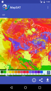
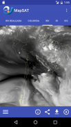
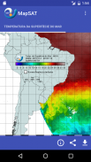
O aplicativo permite a visualização das últimas imagens processadas de satélites meteorológicos para os canais vapor d'água, infravermelho e visível, em formato de imagens simples e realçadas, com cobertura da América Latina. Além disso, estão disponíveis alguns produtos derivados dos dados obtidos por satélite, tais como índice ultravioleta (IUV), temperatura da superfície do mar e vento da superfície do mar.
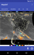
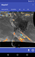
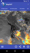
Para monitorar as áreas com potencial de ocorrência de precipitação, o aplicativo MapSAT disponibiliza as últimas imagens de radares meteorológicos espalhados pelo território nacional, pertencentes à rede do DECEA/Redemet, Cemaden, INEA e Ipmet/Unesp.
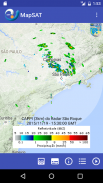
Para grande parte dos mapas, é possível visualizar animações com até 24 imagens.
Na barra inferior da visualização de cada mapa, o usuário conta com recursos para compartilhamento, download da imagem, animação do produto e texto informativo com detalhes técnicos sobre o produto visualizado.
Este aplicativo faz uso da Google Maps Android API para visualização dos mapas na funcionalidade dos Radares.
Os termos de serviço do Google e política de privacidade do Google estão disponíveis nos links:
https://www.google.com/intl/en/policies/terms/
https://www.google.com/policies/privacy/
Veja a nossa Política de Privacidade, disponível em http://satelite.cptec.inpe.br/repositorio9/documentos/apps/politica_privacidade_apps_cptec.pdf
The application allows the visualization of the latest processed images from meteorological satellites to the infrared and visible water vapor channels in simple and highlighted images format with Latin American coverage. In addition, some products derived from satellite data are available, such as ultraviolet index (UVI), sea surface temperature and sea surface wind.
To monitor areas with potential for precipitation, the MapSAT application provides the latest meteorological radar images scattered throughout the national territory, belonging to the DECEA / Redemet, Cemaden, INEA and Ipmet / Unesp network.
For most maps, you can view animations with up to 24 images.
In the lower bar of each map view, the user has resources for sharing, downloading the image, product animation and informational text with technical details about the product being viewed.
This app makes use of the Google Maps Android API to view the maps in the Radars functionality.
Google's terms of service and Google's privacy policy are available on the links:
https://www.google.com/intl/en/policies/terms/
https://www.google.com/policies/privacy/
See our Privacy Policy, available at http://satelite.cptec.inpe.br/repositorio9/documentos/apps/politica_privacidade_apps_cptec.pdf
MapSAT - Wersja 1.13.1
(24-10-2019)MapSAT - Informacje APK
Wersja APK: 1.13.1Pakiet: br.inpe.dsa.app.mapsatNajnowsza wersja MapSAT
Inne wersje


Apki w tej samej kategorii


